Discover it
Canterbury Maps offers access to a wide range of data, most of which is freely available for reuse and/or download from Canterbury Maps Open Data.
Discover Open data in Canterbury Maps through any of the following methods:
Explore

Use the Explore page to find available data
-
Enter a search word,Category and/or District
-
Filter the results to show only Open Data by clicking on the 'open data' icon to the left of the page

-
Select the data you want, this will take you to this data in Canterbury Maps Open Data.
Map viewer

Use the Add Data tool in the Map viewer
-
Open the Map viewer
-
Open the Add Data tool
-
Enter a search word or scroll through the available list
-
Select Download, this will take you to this data in Canterbury Maps Open Data (note: some data sets will not have the download option available, this is because the data does not have the required license)
Canterbury Maps Open Data

-
Go to Canterbury Maps Open Data by selecting Open data on the top menu bar.
-
Enter a search word or select a Category
-
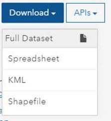
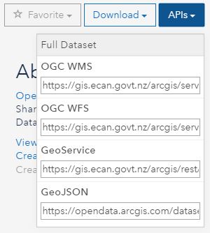
Select Download Dataset or APIs
Download it
1. Select the title of the item you want to download in the open data site by using the steps above. This will open the data details and give you the download options.
Example:

2. Choose from the available download types: Excel Spreadsheet, KML or Shapefile.
Spreadsheet - a way to view the data in a table format
KML - is a file format used to display geographic data in Google Earth.
Shapefile - is a widely supported format for storing the location, shape, and attributes of geographic features.

Connecting to API's
Another way to access the data available on the open data site is to connect directly to an API. By doing this data can be directly pulled into another GIS system such as ArcGISOnline, ArcMap and QGIS.
1. Find the data you wish to access using the steps above.
2. Choose from the available API connections and bring the data into an external GIS system. Read more about how to do this here
