Canterbury Flood Imagery Register
Canterbury Flood Imagery Register
Created by: canterburymaps
Last updated: Tuesday, March 14, 2017
Description
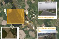
Environment Canterbury monitors flooding in the region, and maintains a collection of oblique and vertical aerial photographs and ground photographs taken during (or following) past flood events. The locations of the vast majority of photographs held by Environment Canterbury have been mapped, but other photographs may exist which have not yet been mapped.For areas north of the Rakaia River, the field of view for each oblique aerial photograph is marked by a line and arrow. South of the Rakaia, oblique photos are currently marked with just an arrow, but these are in the process of being re-mapped in the same format as for those north of the Rakaia. In both areas, the field of view for vertical aerial photographs are marked by a polygon, and ground photographs are marked by a point to indicate the location that the photograph was taken from. Examples of each are shown below.

Note that the photographs have been mapped to varying degrees of accuracy and the markers may therefore not represent the exact field of view or location of the image.
Use the map to pan and zoom to search available imagery. Available imagery can be previewed by selecting a thumbnail in the side bar. Imagery can also be sorted and filtered by date in the side bar menu.
Map Credits
CC BY Environment Canterbury Regional CouncilAccess and Use Constraints
Re-use of this data could be in a variety of maps, web sites, printed material and applications. All data unless specifically stated is licensed under a Creative Commons Attribution 3.0 New Zealand License. 
You MUST attribute the data back to its original creator and have this license associated with the data at all times and displayed on any maps, web sites, applications or printed material using this data.
Map Contents
Basemap:
- {{layersInfo.baseMap.title}}: {{layer.url}}{{$last ? '' : '; '}}
Operational Layers:
- {{layer.title}}: {{layer.url}}