News

NZ National Elevation Programme - NZ's 3D Treasure Trove
The NZ National Elevation Programme
In 2018 Toitū Te Whenua LINZ in partnership with Regional Councils began a project to procure and make available a nationally consistent baseline elevation data set for Aotearoa New Zealand. By 2024, 80% of the country will be covered and this treasure trove of data will be freely available on open licence.
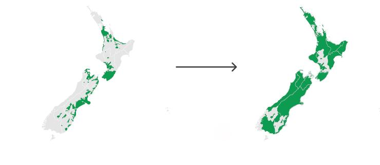
Comparing NZ's current LiDAR coverage in 2020 with expected coverage by 2024
What is elevation data?
Elevation data or LiDAR (light detection and ranging) is a technology using laser sensors mounted on aircraft that fly over a landscape to capture a 3D view of the land. The sensor measures the time it takes for light to travel back and forth from the sensor to the ground. Because the sensor can rapidly pulse a laser beam, it can capture a "point cloud" of highly accurate 3D measurements – like a digital twin of the landscape.
How is this data used in NZ?
This data represents a wealth of information that can help us understand our land, boost economic performance and improve our resilience to hazards and climate change. Below are some examples of uses.
Natural Hazards
New Zealand knows all about natural hazards. LiDAR can be extremely useful in understanding and improving our resilience to hazards.
Earthquake faults can often be seen directly from LiDAR data and it can help us understand our dynamic landscape. The slider below reveals the Wairau fault in the Tasman region of NZ, otherwise hidden by dense vegetation.

Aerial imagery (left) compared with a LiDAR-derived relief map of the same area (right). On the relief map, the fault is startlingly visible, running at an angle across the landscape
Archaeology
With LiDAR being able to pick up such a high level of detail, archaeologists have been using it to uncover stories of the past. It can be used on the ground to scope out buildings or monuments and from the air where the sensors can capture the land surface normally hidden by vegetation.
It has been a breakthrough overseas in sites such as the Mayan city of Caracol in Belize with the data revealing a bustling city where people once thought a rarely occupied ceremonial site used to lie. In New Zealand, its use in archaeology is growing as more data is released. In the Bay of Plenty region the technology has been used to provide deeper understanding and visualisations of historic Pā (fort) sites.

A bird's eye view of Pāpāmoa Hills Regional Park in Bay of Plenty, the location of many pre-European archaeological features including at least 7 Pā sites, marked in red on the LiDAR-derived relief map on the right.
Read the full story here.