Canterbury Contours
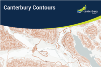
Contours derived from Environment Canterbury LiDAR collections and sourced from LINZ national contour datasets combined for the Canterbury Region.
Created by: canterburymaps
Last updated: Friday, April 19, 2024
Description
Contours for the Canterbury Region derived from various Environment Canterbury LiDAR collections and the University of Otago - National School of Surveying 15m DEM. The combination of these contours has then been supplemented with LINZ's Topo 1:50k Mainland Contours dataset.Areas with Contours showing 1m interval steps are derived from DTM's generated from LiDAR collections.
Map Credits
Environment Canterbury, Land Information New Zealand, University of Otago - National School of SurveyingAccess and Use Constraints

Map Contents
Basemap:
- {{layersInfo.baseMap.title}}: {{layer.url}}{{$last ? '' : '; '}}
Operational Layers:
- {{layer.title}}: {{layer.url}}