Water Quality in Canterbury
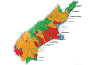
Nutrient Allocation Zones in Canterbury reflect the water quality and amount of nitrate leaching from farming activity in an area and regulate nitrate leaching accordingly.
Created by: canterburymaps
Last updated: Friday, April 19, 2024
Description
Real progress is being made towards setting environmental limits for both water quality and quantity.
We must reduce the amount of nutrients entering our waterways if we are to improve fresh water quality.
In Canterbury, we have for the first time, set limits on the amount of nitrate and phosphate – two of the most important nutrients – that can be leached or discharged from land.
These limits are set in the Canterbury Land and Water Regional Plan and apply to the red and orange areas in this map.
More positively, lots of things are already being done, and plenty more can be done, to improve water quality in both urban and rural areas.
Helpful actions include:
- Following better practices on-farm
- Enhancing biodiversity and ecosystems, focusing especially on water quality
- Improving stormwater management in urban areas
- Improving rules and regulations based on community expectations
- Setting limits for nutrient levels in fresh water to protect the environment
- Working with communities on innovative solutions for our fresh water issues.
All these actions fit with the collaborative Canterbury Water Management Strategy – which sets out a new way to protect and improve fresh water for now and for future generations. To find out more, please visit http://cwms.org.nz/
Map Credits
Environment CanterburyAccess and Use Constraints
 This work is licensed under a Creative Commons Attribution 3.0 New Zealand License
Map Contents
Basemap:
- {{layersInfo.baseMap.title}}: {{layer.url}}{{$last ? '' : '; '}}
Operational Layers:
- {{layer.title}}: {{layer.url}}